In the heart of the Alps
Photos and text by Tuan.
Mont-Blanc
With a few exceptions, all the photographs in this page give an intimate
view of Mont-Blanc, since they are taken while climbing its many faces.
A
global view taken from a distance is availble elsewhere.
Climbers: there are some notes on the
easy routes to the top.
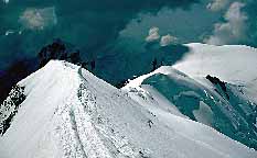
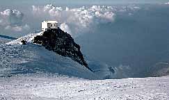 This is the summit of Mont-Blanc, 4807m. The
regular route
, which follows
the Bosses ridge, is extremely popular in summer, as it can be seen from
the well-marked trail. The Vallot hut, pictured on the
right photograph, can be spotted on the rocks at the right of the first
picture. This emergency shelter has saved more lives than any other, but
it is unfortunately badly littered by people attempting the regular route.
This is the summit of Mont-Blanc, 4807m. The
regular route
, which follows
the Bosses ridge, is extremely popular in summer, as it can be seen from
the well-marked trail. The Vallot hut, pictured on the
right photograph, can be spotted on the rocks at the right of the first
picture. This emergency shelter has saved more lives than any other, but
it is unfortunately badly littered by people attempting the regular route.
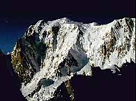
The North face
 The North face of Mont-Blanc, facing Chamonix, is actually its
easiest.
It has gentle (but crevassed) snow slopes,
on which
alpinism (see pictures)
was born, more then 200 years
ago, when Balmat and Paccard reached the summit of Mont-Blanc through
them. By contrast, the Italian side, which comprises the other faces,
is considerably steeper and is a playground for modern alpinism.
The North face of Mont-Blanc, facing Chamonix, is actually its
easiest.
It has gentle (but crevassed) snow slopes,
on which
alpinism (see pictures)
was born, more then 200 years
ago, when Balmat and Paccard reached the summit of Mont-Blanc through
them. By contrast, the Italian side, which comprises the other faces,
is considerably steeper and is a playground for modern alpinism.
The East face
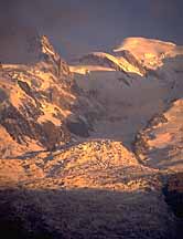
The East face of Mont-Blanc, also called Brenva face, is mostly
covered by very steep snow and ice. A 1400 meter high face, it is
bordered on the left by the Aiguille Noire and Aiguille Blanche de
Peuterey (which form the begining of the Peutery ridge), and on the
right by Mont Maudit.
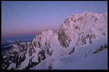


 This series show the progress of the day on the East Face of Mont-Blanc.
The first picture was taken by moonlight, the last one by full daylight,
and the pictures in-between at dawn and sunrise.
This series show the progress of the day on the East Face of Mont-Blanc.
The first picture was taken by moonlight, the last one by full daylight,
and the pictures in-between at dawn and sunrise.

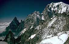
 The two only shelters which can be found on this face are built on
the ridge which is on the center of the picture above. A non-trivial
climb is required just to reach them. The Kufner route which follows the
ridge to the summit of Mt Maudit, traverses an impressive cornice.
The two only shelters which can be found on this face are built on
the ridge which is on the center of the picture above. A non-trivial
climb is required just to reach them. The Kufner route which follows the
ridge to the summit of Mt Maudit, traverses an impressive cornice.


These pictures were taken during a climb of the
Brenva Spur. There is
a mixed/rocky part (left), a sharp snow ridge (middle), and after a steep
slope, you have to find your way up through a dynamic serac system (right).
Pionneered in the XIX century, this was the first major route climbed on
the steep Italian side of Mt Blanc.

 The Red Sentinel
is part of a trio of routes, all established by Graham Browne in
the 30s, which travel right in the
heart of the face. It is an extremely elegant and clever line which remains
sheltered against the large seracs which are the major hazard of this face. The
left picture is looking upwards, the right away from the face.
The Red Sentinel
is part of a trio of routes, all established by Graham Browne in
the 30s, which travel right in the
heart of the face. It is an extremely elegant and clever line which remains
sheltered against the large seracs which are the major hazard of this face. The
left picture is looking upwards, the right away from the face.

 The
Grand Pilier d'Angle,
on the very left of the Brenva face is
a microcosm of alpine terrain, since it has rock, snow, ice, and a
hanging glacier. Its north face is very steep and has only severe routes.
Although Bonatti first climbed it in 62, it is only ten years later
that a second ascent was done thanks to the modern ice-climbing gear.
The
Grand Pilier d'Angle,
on the very left of the Brenva face is
a microcosm of alpine terrain, since it has rock, snow, ice, and a
hanging glacier. Its north face is very steep and has only severe routes.
Although Bonatti first climbed it in 62, it is only ten years later
that a second ascent was done thanks to the modern ice-climbing gear.
The South Face

 The imposing South Side of
Mont-Blanc, whose headwall,
dominated by huge rock pilars,
is extremely steep.
Those visible on the right
are the Freney Pilars, the Brouillard Pilars begin hidden behind the
brouillard (fog).
The imposing South Side of
Mont-Blanc, whose headwall,
dominated by huge rock pilars,
is extremely steep.
Those visible on the right
are the Freney Pilars, the Brouillard Pilars begin hidden behind the
brouillard (fog).
 During the approach from the Monzino hut,
the pilars appear deceptively small because of
the distance, but are more than 500m high.
Separated in two by the Inominata ridge, which begins at the right,
the face
delimited by the Brouillard Ridge on the left (the skyline on the left of
the picture), and the Peuterey ridge (visible on the pciture above)
During the approach from the Monzino hut,
the pilars appear deceptively small because of
the distance, but are more than 500m high.
Separated in two by the Inominata ridge, which begins at the right,
the face
delimited by the Brouillard Ridge on the left (the skyline on the left of
the picture), and the Peuterey ridge (visible on the pciture above)

 This is a very remote corner, which is
a fearsome trap if a storm moves in. Reaching the Eccles shelter
(4000m) requires a long day of climbing from the
Valley. Because of its tragic history, its position and difficulty,
the
central Pilar of Freney
, of which the base is seen on the right
picture, has kept his reputation of being one of the big climbs of the
Alps.
This is a very remote corner, which is
a fearsome trap if a storm moves in. Reaching the Eccles shelter
(4000m) requires a long day of climbing from the
Valley. Because of its tragic history, its position and difficulty,
the
central Pilar of Freney
, of which the base is seen on the right
picture, has kept his reputation of being one of the big climbs of the
Alps.
The West face
 The West face of Mont-Blanc photographed from a commercial airplane.
Also called the Miage Face, it is its loneliest. Cold, not visible
from the valley, it has less appeal, except for those seeking
adventure.
Picture with names overlayed.
The West face of Mont-Blanc photographed from a commercial airplane.
Also called the Miage Face, it is its loneliest. Cold, not visible
from the valley, it has less appeal, except for those seeking
adventure.
Picture with names overlayed.

 During the first solo ascent of the
Jaccoux-Domenech route. Looking down
and sideways to the Bionnassay ridge on the right.
The triangular summit is
Aiguille de Bionnassay, a 4000 meter peak.
During the first solo ascent of the
Jaccoux-Domenech route. Looking down
and sideways to the Bionnassay ridge on the right.
The triangular summit is
Aiguille de Bionnassay, a 4000 meter peak.

 Sunset a few pitches under the summit of Mont-Blanc. I am now above a see of
clouds over the
Brouillard ridge at the left and to the Bionnassay ridge at right, which
frame the Miage face.
Sunset a few pitches under the summit of Mont-Blanc. I am now above a see of
clouds over the
Brouillard ridge at the left and to the Bionnassay ridge at right, which
frame the Miage face.
Middle mountain |
High mountain tour |
Alpinism |
Mont-Blanc
Alps menu
Copyright (c) 1988-1992 Quang-Tuan Luong

 This is the summit of Mont-Blanc, 4807m. The
regular route
, which follows
the Bosses ridge, is extremely popular in summer, as it can be seen from
the well-marked trail. The Vallot hut, pictured on the
right photograph, can be spotted on the rocks at the right of the first
picture. This emergency shelter has saved more lives than any other, but
it is unfortunately badly littered by people attempting the regular route.
This is the summit of Mont-Blanc, 4807m. The
regular route
, which follows
the Bosses ridge, is extremely popular in summer, as it can be seen from
the well-marked trail. The Vallot hut, pictured on the
right photograph, can be spotted on the rocks at the right of the first
picture. This emergency shelter has saved more lives than any other, but
it is unfortunately badly littered by people attempting the regular route.


